

Making Your Campaign World Come Alive with a Map

If you have ever read a fantasy novel, you probably look at the map of the world first. And then, while you are reading the book, you refer back to the map whenever the heroes are arriving at a new place. Fantasy is the only genre where this is normally done.
In a novel set in the real world, there is no need to provide a map to show where New York or London is. In science fiction, maps are almost never used because the characters travel so fast that movement overland is not really an issue. But in fantasy, with its long journeys overland, featuring visits to forests, swamps, cities, villages, and fantastical places, the reader needs a map to make sense of it all.
If you want to make sense of your campaign world, and you are in the fantasy genre, then you should have a map. If you want your players to make sense of your campaign world, then you should have a map. You don't need a map right away, perhaps you can start out the campaign with a single village and a nearby ruin, but once your players have finished that first adventure, they will want to travel elsewhere, and you will need a map.
You don't have to have a map of the entire world, in fact, that is not really feasible. What you should start with is a map of a single kingdom, or a large province within a kingdom, or maybe just a county.
You can draw a map on paper, or with a computer. If you draw it on paper, you can use butcher paper if you want a really large map covering a large territory, or you can draw it on an ordinary sheet of copy paper.
I would suggest drawing your map on hex paper, which can be purchased at a game store or online. Large hexes are best, one inch across. Smaller hexes will obscure too many details, making things hard to see.
There are computer programs which can be used to build a campaign world map, the best is Campaign Cartographer 3 (CC3). I use this program exclusively now for overland maps, though I still use graph paper for dungeons, towns and buildings. CC3 is a complicated program with many features, and it has a steep learning curve. It is possible with CC3 to have elaborate maps of publishable quality, but that requires the use of many features that I never bother to use. I want a functional map, not a piece of art.
CC3 also has supplements which allow you to draw dungeons and cities, but I don't recommend purchasing them. The options of images is too limited, in my opinion, to make it worth the extra money. I can always make a better dungeon, and make it faster, using graph paper and pencil.
Playing without a map
I have parts of my world not mapped, and my players didn't seem to care. But there was no consistency in where cities were located, or how far apart they are. These "off the map" adventures happened in what I called the "Holy Land" but it was limited to a single adventure. Had I kept the campaign located in the Holy Land for more adventures, I definitely would have drawn a map.
Example
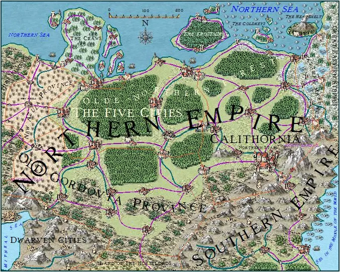
I started off with a map of Gordovia using CC3, and the surrounding lands. I have not mapped my entire world. But I have a continental scale map, including Gordovia, mapped on an ordinary piece of copy paper, showing only nation borders and major cities.
I have two other CC3 maps, one showing the Kingdom of Aquila and surrounding lands, and a third map showing an area with numerous small kingdoms, principalities and magocracies. These maps show a very large area spanning hundreds of miles. I have actually mapped far more than I will ever use, but having these maps gives me an idea of where things are.
I only recently drew the map of the Empire. For other places, perhaps I will never need maps. I have a rough idea what's there, but the players may never go to these places. If they do, I will prepare maps.
Time Involved
Drawing a good map of a major section of your world is time consuming, and there's no shortcuts. You will need to draw coastlines, place mountains, draw rivers, and then settlements like cities, towns, and villages. Also, you will need forests, swamps, scrublands, plains, blighted areas, and farmland. Finally, put in ruins for the players to explore. It helps to know the history of the world you are building, but sometimes you have to draw the map before you create the history.
When's the best time to draw a map?
You should draw the map as soon as possible. You can start with a village and a nearby ruin, but after that the players will want to travel somewhere else and you will need a map.It's too late to draw a map while playing a session, but if you're really desperate, you can draw a barebones map showing major features like roads, rivers and cities and then make the real map later based on what's revealed in the session.
Improvising
When you're improvising, you can play without a map, but write down what you tell the players, like how far it is to the next village, and in which direction they are going. That way, you can return to your notes and draw a map consistent with what you have told the players.
Uploading maps to Scabard
With a Hero subscription, you can upload any number of Campaign or Place maps to your campaign on Scabard, and then link to other pages in your campaign with pins.Got a great map you'd like to share? Post your maps in the comments below!